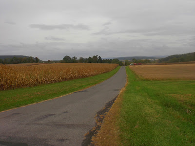
After a bit, I turned onto the gravel Oman Road, where the descent continued through the woods. At the bottom of the hill, it came out into open fields and I had to climb a little to Kline Road. Here, I turned right and continued ascending past some residential areas. I saw spectacular views of Knob Mountain, and made another panorama.
Four-shot panorama from Kline Road (
view larger).
I then turned onto Trump Road and enjoyed a wild, bumpy ride downhill, barely staying in control the whole way. It was fun to go down that monstrosity instead of up it for once. While going down, I imagined that it was as technical as one could get and still have a road--but I later proved myself wrong. Soon after reaching the bottom of Trump Road, I arrived at Rohrsburg Road and headed north for several tenths of a mile before turning onto Belles Road, unexplored territory.
Cliffs, with the usual horde of plantlife clinging on
I thought Belles Road would be sweet and innocent!
Belles Road, strangely enough, rose hundreds of feet on gravel through the deep woods. Once the cars on Rohrsburg Road were out of earshot, there was no sign of human civilization except for the road and the posted signs that were plastered on every tree. After a while, the road became paved and the woods thinned out a lot. I then turned onto Deer Run Road and continued rising, eventually reaching open fields and the ride's high point.
The road suddenly turned to pavement at the Fishing Creek Township line. Almost as if Fishing Creek Township decided to pave the road, but Orange Township said "No way! We have better things to do than pave roads that get maybe two cars a day."
Lazing around at the top of the hill
Deer Run Road turned to gravel again, but this time it was more like rocks than regular gravel. Slow going. Presently the road entered the woods and became normal gravel, before leaving the woods and turning paved, but becoming very narrow. Roads are strange. After a gentle little descent, I reached Schultz Road.
Looking back on Deer Run Road. That white gravel was tricky.
Deer Run Road again
It's funny how all three of these pics are the same road, and that they were all taken within a mile of each other.
Schulz Road was gravel (again) and quickly headed bumpily down through the woods. I wanted to take some pictures, but was having too much fun to stop. Eventually, I did stop to take one picture near the bottom. But I quickly built up speed again. I did the 15th mile (all descent) in 2:59. Pretty respectable for crazily twisting gravel roads.
Approaching Rohrsburg
At the end, I took a little gravel side road to Utt Road, crossed Green Creek, and headed past some farms. Along the way, I noticed that my right pedal had a big crack in it (!) but it held up. I headed over to Turkey Path Road. Whereas I've always gone up Trump Road, I almost always go down Turkey Path Road; this time I would be going up for a change. The ascent was difficult, slow going, but I did survive. There were a few close calls, though. So to speak. Once, a dog charged out of its yard and chased after me for a bit, barking, before growing bored. Another time, while stopping near an overlook showing Greenwood Valley, I heard about half a dozen gunshots before scramming.
Vandalized street sign
Rising on Turkey Path Road
Moar climbing
Turkey Path Road spit me out on Bowmans Mill Road and I headed south. Along the way, I passed Montaque Hollow Road, a no outlet road that upon further inspection proved to go nowhere interesting. I continued on to Welliversville Road.
Montaque Hollow Road
Welliversville Road was scenic in a quiet way, but a bit boring. No spectacular uphills or downhills. But along the way, I did suddenly spot a very rough-looking gravel road. Naturally, it called to me. I explored the road, which was Huckleberry Hill Road (there was definitely a hill, but no Huckleberries). It was probably even more technical and hilly than Trump Road, as it rose about 200 feet in just over 0.4 miles. Really, it was more of a one-lane dirt track. I took lots of pictures on the way up.
Huckleberry Hill Road. It had a sign saying "Travel at your own risk" with no explanation. I guess none is needed...
Looking back
Crawling slowly upwards
Another view

Hideously steep
Summit

Looking south and west from the summit (
view large)
Huckleberry Hill Road then descended for a short while to Fester Road, which descended to Lick Run Road. I headed straight onto Schatz Road, which was possibly the most technical road of all, in the beginning at least. There were a lot of leaves and big rocks strewn all over the road in the beginning. And there were deep, massive ruts that gave my bike a good shaking every time I went over them. After a while, it mellowed to a dirt road, and then to a gravel road, but then it began to ascend. Presently I came out of the woods to a pretty view of a power line passage.
Fascinating beginning to Schatz Road
Ascending
Power lines heading off into the distance. Some say power lines are ugly. That is subjective.
One-lane gravel road
In addition to fields and power lines, I even saw a couple of buildings. Strange that people live here. I wonder how they get down without an ATV.... After the buildings, I made a short descent to Mount Pleasant Road. Looking back, it does seem easy to miss from that side.
Schatz Road again. Funny that it has a road closed sign on this end, but not the other end.
The last eight miles weren't that remarkable. All of the new exploration and most of the gravel was behind me. I headed east for a mile or so on Mount Pleasant Road before reaching Whites Church Road. From there, the last seven miles were pretty much what they always are. Not much to report about that. My time was 2:26:40 and my pace was 5:03/mile. All that gravel slows a person down.
It was also very hilly, with 2740 feet of climbing (5488 feet of elevation change) and one 500-foot climb in the middle.
Route map
I'm hoping to do one more really long ride before it gets cold, but time is running out according to the weather forecast.


