Wednesday, July 8, 2015

Turbotville Tragedy

On Sunday, I attempted what would have been the longest ride ever, a 54-mile expedition to the borough of Turbutville, deep in Northumberland County. The good news? I made it to Turbotville. The bad news? I didn't make it back (well, I did, but it was on four wheels, not two). I made it 31.6 miles, which is respectable, but not what I was aiming for. I missed my chance to leave in the morning, so I departed around 1:30 P.M. I rode over to Arbutus Park Road and then took the shortcut to Upper Campus. The grassy trails had recently been mowed, so they were somewhat rideable, as they were back in April. A little less than a mile in, I came to some of the best scenery in Bloomsburg.
 Entering the shortcut
 Beautiful scenery, now in summer colors
The trail
Soon after the clearing, I reached the road and descended from Upper Campus into town. After some steep descent on Turkey Hill, I reached First Street, where I was on for most of the way through Bloomsburg. The town is actually pretty hilly in many places, and First Street is one of those places.
First Street
At the end of First Street, I turned onto West Street, which took me to Main Street. Here, I was forced to wait for--I kid you not--five minutes before the light changed. When at last it did (I was beginning to lose track of what day it was), I rode down Main Street and then across Fishing Creek into Fernville. Fernville, thankfully, had no stoplights and I made good time, heading out into rural-ish areas on Red Mill Road before long. After a while, I turned onto Frosty Valley Road and went down a short hill and across Hemlock Creek. Frosty Valley Road went in a generally upwards direction for a few miles, rising about 200 feet in 2.5 miles, past farms and houses. A few tiny unnamed creeks, swollen by recent rains, crossed under the road.
 Hemlock Creek
 Pylon (I love these)
 Frosty Valley Road
Barn next to curvy road
After a while, Frosty Valley Road became a long, straight descent to the Columbia County/Montour County border. At this point I crossed Interstate 80 on County Line Road and then began heading into Montour County on Kashner Drive. This part was gently rolling, with fields and a bit of forest. After a while, I came to Columbia Hill Road, and then Trump Road, where there were a few houses. At the end of Trump Road, I turned onto Creek Road, which ran alongside a cliff overlooking Mahoning Creek.
 View from Kashner Drive
 Field
Queen Anne's Lace
At the end of Creek Road, I rode a short distance on Pennsylvania Route 642 and crossed Mahoning Creek before turning onto the non-busy and forested Spike Blue Hollow Road. Up to this point, I had mostly been retracing my steps on the Washingtonville ride back in may, but in the reverse direction. However, on Spike Blue Hollow Road, I turned onto Hess Hill Road, which was unexplored territory.
 Spike Blue Hollow Road
Hess Hill Road, unexplored territory
Hess Hill Road proved to be a hideous hill that rose nearly 350 feet. For a while it climbed through the woods, but eventually it began going past houses, and then fields. Eventually, near the end of the road, I came to a bizarre impasse: the road went on, but for reasons unknown someone had dragged a private road sign out onto the road, blocking half of it. It seemed like a mistake or a joke, but I wasn't about to take any chances, so I took a 3-mile detour.
Field
The first part of my detour took me down Bull Run Road, a 340-foot descent through woods, with a few houses in the distance. At the bottom of the hill, I came to an unmarked road, to be bewilderment. I turned right and began riding along, looking for a street sign. After a while, I noticed Interstate 80, which was rather odd. It eventually dawned on me that I had descended all the way to McCracken Road, which I had explored twice last fall.
 Wild meadow, with Interstate 80 in the background
McCracken Road
McCracken Road was fairly flat, but after a while I came to Cameltown Hill Road, which would take me back to my planned course. As the name might suggest, it was most definitely not flat. It rose endlessly, climbing 370 feet in a mile and a quarter. It just went on and on and on. I stopped for pictures a couple of times.
 Climbing
 And more climbing
Wheat field
Eventually I turned onto Wagonwheel Hill Road, a fast curvy descent through the woods. It was a nice change from the climbing on Cameltown Hill Road and I approached 30 miles per hour at points. But alas, it was not to last. I immediately began another 300+ foot climb on Indian Run Road. As one might imagine, the road climbed up the valley of Indian Creek, which I caught a few glimpses of. It was just a typical small roadside stream. At the top of Indian Run Road, the hill continued onto Turtleback Road, which took me to the highest point on the whole ride. I could see many miles to the south.
 View from Turtleback Road
Looking south from near the ride's highest point, at about 980 feet.
After the peak, Turtleback Road began descending. This was a much more twisting and serpentine descent than Wagonwheel Hill Road, and the road wasn't as well paved, so I was going at bit slower. At one point there was even a horseshoe bend in the road.
Very sharp turn. I wonder how cars manage it.
Soon after the crazy horseshoe bend, I exited the woods and left the Columbia Hills behind me. I could see across the valley a long way, past the Montour County power plant and to the Muncy Hills. A short distance further on, I began heading west on Hillside Road, which took me to Pennsylvania Route 54.
Looking back on Hillside Lane
After crossing Route 54, I headed in a northwesterly direction. The worst of the hills were behind me, but there was still plenty of climbing to do. After a while, I turned onto an unpaved road that ran through some fields before crossing the slow and muddy Chillisquaque Creek via an oddly-shaped bridge.
 Hill
 Strange square bridge with a low clearance
 Unpaved road
Clearing
I continued heading north and west, across Pennsylvania Route 254 and through some more fields. At one point, I missed a turn, but I noticed within a couple of minutes and turned around. It wouldn't have mattered anyway since both routes went to the same place. I was surprised to find that there were some seriously rolling hills in this area; on Google Maps terrain view, it looked mostly flat.
 View of the power plant
 A field of something
Looking north to the Muncy Hills
The navigation was a bit tricky and involved frequent consultation of the map, but eventually I began seeing signs for Turbotville.
About time
I passed by a couple of Amish buggies going in the other direction before turning onto T617. A bit further on, I turned onto a badly paved road that passed through a swamp and crossed Beaver Run. The road continued past some farms before crossing a railroad line. I then turned left and crossed the railroad line and Beaver Run again. Turbotville was now only a mile or so away.
 Cornfield
 Beaver Run
Railroad
I entered Turbotville with little warning, but gradually houses began to replace fields. After a while, I turned onto a side street, which took me to Route 54/Route 44. My parents were waiting at the post office parking lot; apparently I had arrived an hour later then when I had planned. It was pushing 5 P.M., so I decided to throw in the towel there instead of continuing on, as it would've otherwise been pushing 8 P.M. by the time I got back home. I only got in 31.6 miles, but still there is a silver lining: the past week was my most active week, with 73.4 miles being covered. Far short of the 100 I had been aiming for, but still....
 Field on the outskirts of Turbotville
 Building
The End.
My time was 2:27:15 and my pace was 4:39/mile.
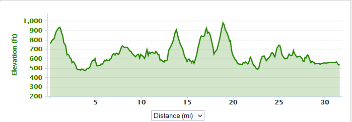
Elevation gain: 2296 feet; total elevation change: 4819 feet. Highest point was 984 feet, lowest was 473 feet.
Route map. (source)(license)

Thursday, July 2, 2015

Briar Creek Reservoir

Yesterday, I did a 26.8-mile ride out to the beautiful Briar Creek Reservoir and the slightly less beautiful (but still pretty) Briar Creek Lake Park. I left around 4:30 P.M. and rode over to Tower Road and then down Neufer Hill Road, nearly fast enough to keep pace with the cars. At the bottom of the hill, I made a sharp left on Shaffer Road and began a 260-foot climb. Shaffer Road is longer and higher than Neufer Hill Road, but not as steep. For a while, it climbed through the woods, but eventually it went past open fields and houses before crossing under Interstate 80 and taking me to a crossroads.
 Shaffer Road
Coming out of the woods
Instead of turning onto Horse Farm Road, I continued straight on Shaffer Road. It descended through some pretty fields of corn/sorghum, wheat, and weeds. After several tenths of a mile, the road dead-ended into Ridge Road, the site of the old 20K (actually 12.2 miles) course that was a favorite of mine some years ago. Ridge Road went past some houses and a stable before dipping down into a little forested hollow. It was a short hill, so I was able to power up the other side in one burst. Once I was there, there were more fields.
 Mountain scenery
 Horse farm
More rural scenery
Soon after that, I crossed Hidlay Church Road and continued east on Ridge Road, going over a few more small hills. There was a nice descent near the Brookside development, but it was followed by a longish, slow climb. After a while, I reached the top of that and left pavement for the first time, turning left onto Adams Road.
 Staghorn sumac
 Ridge Road
Leaving pavement
Adams Road descended steeply for a bit and then leveled off. But then it briefly became very steep before flattening out again as it passed through a swampy area and crossed West Branch Briar Creek. The road then began to rise again before reaching Fowlersville Road. On the other side of Fowlersville Road, the terrain shifted from gravel to some pinkish-gray surface in between pavement and gravel. I passed by more fields, with some lovely mountain vistas in the distance.
 Colorful garden
 Vista of Nescopeck Mountain. The water gap through which Nescopeck Creek flows is just barely visible here.
Curious road surface
At the end of the road, I turned onto another road. This one was definitely paved, but very bumpy. It almost immediately began a very fast and steep descent. There was water all over the road, so I managed to get myself soaked, but I dried off soon enough. At the bottom of the hill, I came to Fester Hollow, a small, rushing stream. I had ridden up this hill a couple of times before and it was a brutal one. It was nice to feel the wind in my face instead for once.
Fester Hollow
Soon after crossing the wooden bridge over Fester Hollow, I crossed Pennsylvania Route 93 and continued onto Slowick Road. There were a few ups and downs and I saw some more amazing views of Nescopeck Mountain to the south. Eventually, I made a steep descent to Lake Road.
 I just love these views of fields and distant mountains.
 Slowick Road
 Yet another mountain/field vista
Whee!
A few tenths of a mile through farmland on Lake Road brought me to Briar Creek Lake Park, where I turned onto a grass trail around the 51-acre Briar Creek Reservoir. Riding on grass is always two or three times harder than riding on asphalt, so it was very slow going, about nine or ten miles per hour. It was also a bit muddy (it was by the side of a lake, after all), so my tires turned up a lot of water.
 Black-eyed Susans
Lake Road
 Briar Creek Reservoir
 The reservoir again
Trail
After a little while, I rode up a hill (a grass-covered one, no less) to Park Road and took that to the upper part of Briar Creek Lake Park, a bit further away from the lake. I meandered around for a while in this part of the park, which was hillier than the lower part of the park and passed through some attractive wild meadows. I also saw yet more cultivated fields and mountains. After a bit of exploration--there wasn't much to explore--I rode down a hill to the lower part of the park, and from there up onto the grass-covered dam on the eastern side of the lake. The trail went along the top of the dam to another parking lot, and from there I left the park.
 The lake
 I've never seen model aircraft here.
 My bike is enjoying the scenery as much as I am.
 Dam this place!
 The lake from the east side
Upon leaving the park, I began heading west on Evansville Road. This stretch was a bit dull and quiet, especially compared to the scenery of Briar Creek Lake Park. After a while, the road began to climb a bit, enough to be felt, but not enough to look steep. Those climbs are annoying. On the positive side, East Branch Briar Creek was very pretty as it rushed along over a stony streambed. I even saw a tiny waterfall, almost obscured by undergrowth.
Climbing...
I eventually turned onto Croop S Road to do yet more climbing. This part was actually steep, unlike Evansville Road. A very tiny roadside stream--unnamed and even smaller than East Branch Briar Creek--was distinctly audible but barely visible. After a while, I came out of the woods and reached the top of the hill.
Coming out of the woods
The next few miles had half a dozen or so little ups and downs of a hundred feet or less. Croop S Road first descended into a valley and then crossed Briar Creek before beginning a steep ascent. The climb was fairly short and took me to State Route 2012, where I stayed for a couple of miles. This stretch was mostly unremarkable, but for a few more field-and-mountain vistas. I also passed right by a herd of cows near the end of the road.
 Farm, with Knob Mountain in the background
 Endless field of wheat
A field of something else

State Route 2012 intersected with Route 93, which I crossed. I then began ascending on Shellhammer Road before making a fast descent into a hollow. This was followed by yet another climb, this time on Hosler Road. I reached the summit of Summer Hill, at an elevation of 979 feet, which was the highest point on the ride. Then, I began to descend.
 Orchard
 Knob Mountain
Mullen
Hosler Road dead-ended into Cabin Run Road, which continued descending along the side of a ravine. Naturally, Cabin Run flowed at the bottom of the ravine. I tried to get a picture of the road, but couldn't quite capture it well enough. Still, I made very good time, and continued to do so as I turned onto Fowlersville Road, and then Harris Road, and then Ridge Road.
 Harris Road
This is the last wheat field, I promise.
I rode hard all the way up Shaffer Road, hoping to get under a 4:40/mile pace. Then I descended for a while on the road, retracing my first few miles. I got to the bottom of Shaffer Road around mile 24.8. At that point, one last major hill remained: Neufer Hill Road. I made my way up that, somehow staying under a 4:40 average pace (for the whole ride, not for the hill; that would be impossibly fast on an uphill). From there, it was pretty much a walk in the park to Shawnee Road.
Shaffer Road
I only said that there would be no more wheat fields. I didn't say anything about other kinds of fields.
My time was 2:04:43 and my pace was 4:39/mile. A bit slower than many of my rides back in May, but faster than most of my June rides.
2301 feet of climbing, 4605 feet of elevation change. Highest elevation was 979 feet, lowest was 499 feet.
Route map. (source)(license)